
A259 Hove to Portslade Active Travel Scheme: Construction to Begin With Fourth Avenue to Hove Street
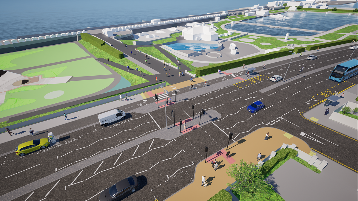
How the A259 near Hove Lagoon would look under the scheme. Image: Brighton & Hove City Council
Brighton and Hove City Council will begin work in the coming weeks on the A259 Hove to Portslade Active Travel Scheme, which adds a separated two-way cycle lane, new pavements, bus stops, crossings and parking along the seafront road between Fourth Avenue and the city's western boundary. Work starts with the section from Fourth Avenue to Hove Street, and a work compound will be set up on the south side of the A259 opposite Westbourne Villas. The council says the scheme is funded by £4.3 million from Active Travel England and £2.7 million from its own Local Transport Plan spread over three years, and that access to homes and businesses will be maintained throughout.
The council's project page had said work was scheduled to begin in September 2026, and its 30 September announcement says it will now begin in the coming weeks. The council's consultation report splits the scheme into phase one from Fourth Avenue to Wharf Road and phase two from Wharf Road to the city's western boundary. This article covers what is being built, what changes for drivers, how the work will affect people living and working along the route, what the 2025 consultation found and how the design changed, and what comes next.
What is being built
The council's scheme information sets out the changes in detail. Its 2025 announcement described the route as a key part of the city that includes the new Hove Beach Park facilities and will be home to a new King Alfred Leisure Centre.
- A separated two-way cycle lane
The council says there is currently no separated cycle route west of Hove Lagoon to the city's western boundary, even though the A259 is part of National Cycle Network route 2. - New pavements and bus stops
Bus stops along the route have been reviewed and, where appropriate, moved. The council is using bus stop bypasses, where the cycle lane runs behind the boarding area, with zebra crossings across the cycle lane, tactile paving, a raised cycle lane at crossing points and islands to get on and off the bus. - Safer, better aligned crossings and junctions
Some crossing points have been redesigned since the first consultation, and the Tandridge Road bus stop stays where it is. - Loading and disabled bays
The council says the scheme adds 12 disabled bays, 8 loading bays and 10 electric vehicle charging bays. It also says the new design provides 4 additional loading bays for the parade of shops near the King Alfred Centre, alongside the 2 already there, with more loading bays for businesses at Hove Beach Park and near Boundary Road, where Ocean Sports and Pets Corner are.
The council's detailed plans run to 16 sheets marked 'for construction', and it says they are provided for information and are subject to change during construction.
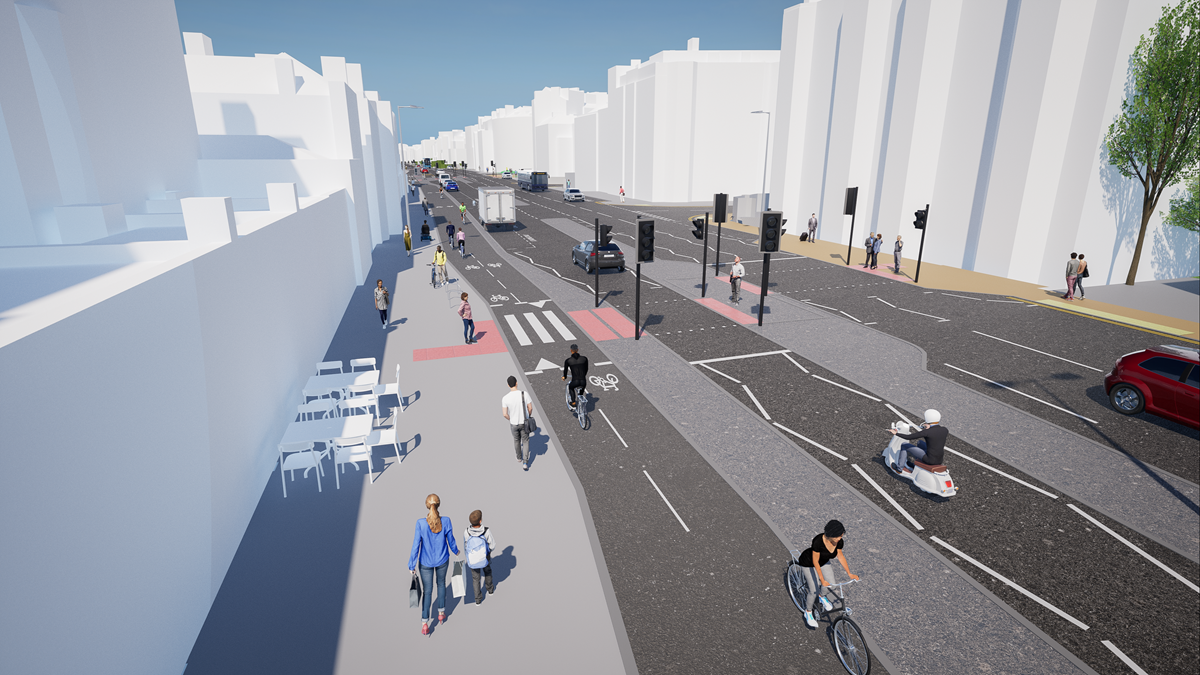
A visualisation of the A259 at Victoria Terrace under the scheme. Image: Brighton & Hove City Council
What changes for drivers and parking
One westbound traffic lane will be removed between Fourth Avenue and Hove Street to make room for wider pavements, the cycle lane and parking and loading spaces. The council says removing the centre island instead, to keep two lanes in each direction, would be costly and would not give good value for money. It says the highest hourly westbound flow recorded in the project area in the past decade is 1,103 vehicles, that one lane will still have capacity for 1,620 vehicles an hour, and that 80% of vehicles stay in the lane they were in when they leave West Street, where two lanes become one.
There will be a left turn ban into Hove Street South. The council's surveys found that of the 8,500 to 12,000 vehicles travelling westbound at that junction each day, only around 200 turn left into Hove Street South. Vehicles can still reach Hove Street South and the King Alfred Leisure Centre car park from the north and west.
Some under-used parking on the south side of the A259 between Hove Lagoon and Boundary Road will be removed because of road width, and the council says it has kept parking where it is used most, outside businesses and near Hove Lagoon. Between the Boundary Road and Church Road junctions there is not enough space for a separated cycle lane, so the council plans a widened shared pedestrian and cycle space nearly double the current pavement width. It says footfall is very low in that section.
How the work will affect residents and businesses
The contractor, Edburton, will give information to properties before work starts in each section, including contact details. The council says the work will be delivered in phases to limit disruption, and has set out what to expect:
- 1Access stays open
Access to premises will be maintained. When work is immediately in front of properties the contractor will talk to occupants and owners first, and temporary loading provision will be provided. - 2The A259 stays open for most of the work
Some short, advertised closures will be needed for overnight resurfacing. - 3Side roads will close briefly
They will be closed for short periods when work is next to junctions, with alternative routes provided. - 4Night work is limited
The council says night work will be kept to a minimum and only needed for resurfacing, to reduce noise for residents. - 5Events continue
Events that pass through the area will carry on, with work areas adjusted in advance.
The council's page on access during construction has the full detail.
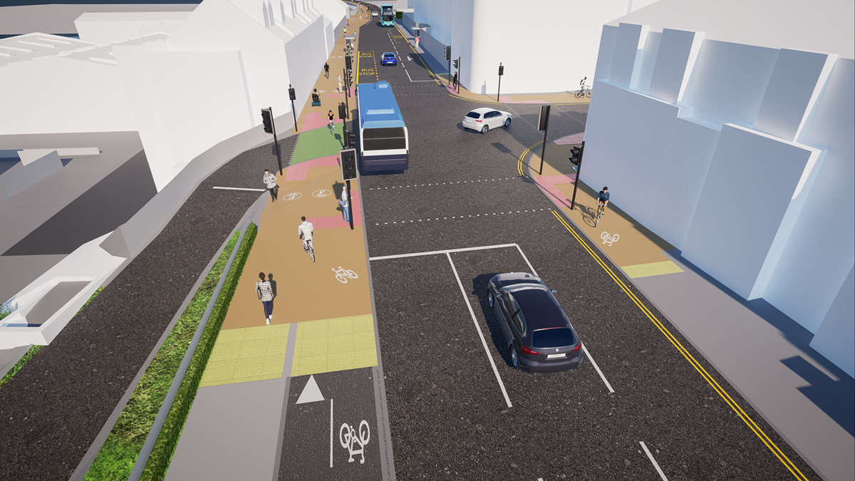
A visualisation of the Boundary Road junction under the scheme. Image: Brighton & Hove City Council
What the 2025 consultation found
The council consulted from Monday 16 June to Sunday 27 July 2025 and received 910 responses once duplicates were merged, according to its consultation report. It sent leaflets to 8,561 addresses along the route, held in-person events at Hove Lagoon, King Alfred Leisure Centre and South Portslade Community Centre, and ran a disability group workshop with Possability People and BADGE. Residents made up 87% of respondents, and 65% were in Hove and Portslade (BN3 and BN41 postcodes).
The report defines support as strongly agree plus agree. These are the phase one results for the main proposals:
- 68.2%Support for upgraded, relocated or new pedestrian crossing points
- 62.8%Support for the upgraded cycle route, with 32.3% opposed
- 63.6%Said the proposals would improve safety for cyclists, and 61.8% said the same for pedestrians
- 36.4%Support for more loading bays, the lowest of any proposal, with 38.6% neither agreeing nor disagreeing or not sure
Opinion was more divided among people who drive through the area every week. The report shows 45.6% of them supported the upgraded cycle route and 48.9% opposed it. For disabled people, 54.1% said the phase one proposals would improve safety, 26.5% said they would not and 19.4% were not sure.
How the design changed
The scheme then went to a statutory 21-day Traffic Regulation Order consultation in early 2026. Changes the consultation report and the council's feedback page record include:
- Crossings
A new pedestrian crossing near St Keyna Avenue, and a redesigned crossing near St Aubyns South so that a right turn ban is not needed. - Bus stops
The Tandridge Road bus stop stays where it is rather than being relocated from outside the Vega building on Kingsway. - Parking
Parking is kept outside The Gather Inn on Kingsway, with more parking mitigation where possible near St Leonard's Road and St Leonard's Avenue. - Cycle lane
A wider buffer next to parked cars, extra safety measures on shared use sections, and work with West Sussex County Council to see whether the two-way lane can open sooner between the Church Road junction and the city boundary. - Green space
Additional green space and planting where possible.

The Tandridge Road bus stop will remain following resident feedback. Image: Brighton and Hove City Council
Councillors agreed to move forward with the scheme, and the council's announcement that work was set for an autumn start followed.
What the council said
Councillor Trevor Muten, Cabinet member for Transport and City Infrastructure, said:
It's fantastic to see construction starting on this important scheme, which will transform how people travel along one of the city's busiest corridors.
He said the council considered the space carefully to develop a design that is accessible and keeps the city moving, and said the scheme will provide safer routes for people walking, wheeling and cycling, improve accessibility and crossings and create a more attractive and welcoming space for residents, businesses and visitors. He also said:
This is a significant investment in the city's transport network and an important step towards making it easier for people to choose sustainable ways of getting around.
The next stage: Fourth Avenue to West Street
As construction begins, the council is asking residents for their views on extending the A259 improvements east from Fourth Avenue to West Street in Brighton. Its 14 September announcement says the proposals would replace the westbound cycle lane separated by plastic wands and the eastbound lane next to the pavement with one two-way lane separated from traffic and pedestrians. It covers two sections, phase three from Fourth Avenue to the Peace Statue and phase four from the Peace Statue to West Street, with improvements around Hove Lawns, the Bandstand, Shelter Hall, the i360 and the Brighton Centre.
The council says it has secured £780,000 from Active Travel England and that nearly £4 million has been allocated by the Department for Transport over four years. The consultation, including a flyover video of the proposals, is on the council's Your Voice platform, and our earlier article has the closing date and the full plans.

Phase 3 runs from Fourth Avenue to the Peace Statue, Phase 4 from the Peace Statue to West Street. Image: Brighton and Hove City Council

How the junction of Kingsway and Grand Avenue could look under the A259 plans. Image: Brighton and Hove City Council

The proposed A259 layout on Kingsway, Hove. Image: Brighton and Hove City Council

Looking west from the Peace Statue, as proposed. Image: Brighton and Hove City Council

Looking west along King's Road from opposite the Brighton Centre, as proposed. Image: Brighton and Hove City Council

Technical drawing, sheet 2 of 3: Brunswick Lawns to Bedford Square. Image: Brighton and Hove City Council

Technical drawing for King's Road, Bedford Square to Shelter Hall. Image: Brighton and Hove City Council
Get updates and read the plans
To receive regular newsletters with scheme updates, email transport.projects@brighton-hove.gov.uk and include 'A259 Hove to Portslade' in the subject heading. The council says information about the work schedule is coming soon.
A259 Hove to Portslade Active Travel Scheme, council project page
Detailed plans for the scheme, 16 sheets
Download the detailed plans (PDF)
2025 public consultation report
Download the consultation report (PDF)
Hove to Brighton extension consultation, council announcement
More from ImJustBrighton
→ A259 Hove to Brighton Cycle Lane Plans: 70 New Parking Spaces and a New Two-Way Lane
→ King's Road Arches Work to Start in October as £22 Million Phases 4 and 5 Get Under Way
→ £1 Whitehawk Link Bus Fare Extended to March 2027 as Pride in Place Board Sets Out Its Plans
